
The History of Tamarindo: From Ancient Civilisation to the Most Famous Surf Town in Central America
Spend enough time in Tamarindo and you start to notice something. Behind the surf schools and the taco restaurants and the digital nomads working from beach cafes, behind the boutique hotels and the catamaran tours and the sunset cocktail crowds, there is a layered and genuinely extraordinary story about how this stretch of Pacific coastline became what it is.
Most people who come here for a week never go looking for it. I spent months in and around Tamarindo across this trip, and the more time I spent, the more I wanted to understand what happened here before the surfboards arrived. The answer runs from ancient civilisation through colonial brutality, through a woman with dynamite and a vision, through a Texas businessman and a legendary surfer, through a film that changed everything, and finally into the town I have been writing about since January.
This is the history of Tamarindo. It is a better story than most people know.
10,000 Years Before Any of Us Arrived
The Nicoya Peninsula, where Tamarindo sits, has evidence of human habitation stretching back at least 10,000 years. The first peoples here were nomadic hunters and gatherers moving through the coastal forests and river valleys of what is now Guanacaste, living off the land and the sea in ways that left shell middens and stone tools as their signature in the archaeological record.
By the second millennium BC, more permanent settlements had emerged. Communities grew, hierarchies formed, and by approximately 300 AD the region had shifted from egalitarian tribal structures into organised chiefdoms with leaders, religious specialists, trade networks, and territorial complexity that archaeologists continue to document in the soil across the peninsula.
Then, around 1200 AD, the people who would define this region for centuries arrived from the north.
The Chorotega: The People Who Built This Land
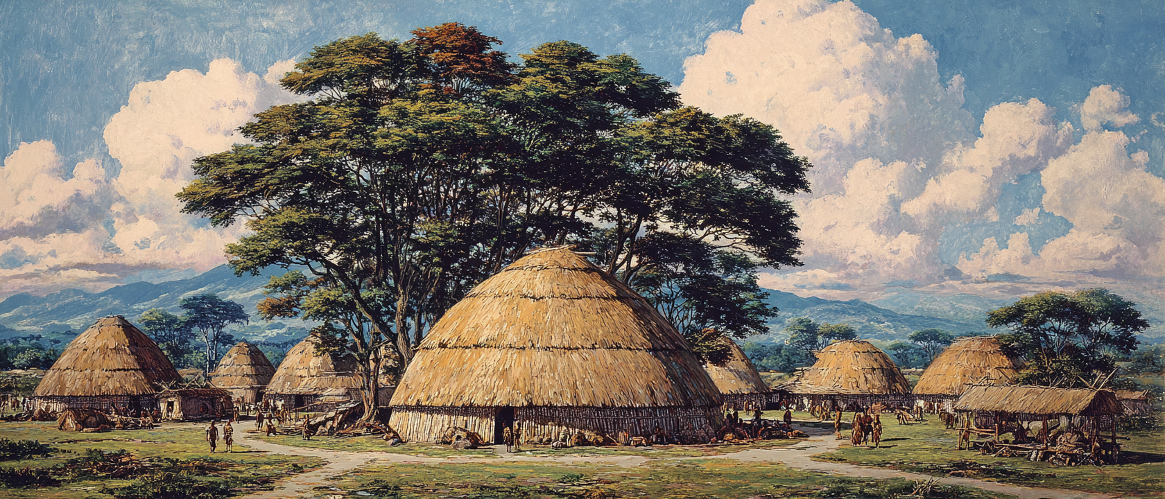
The Chorotega migrated south from Chiapas, in what is now southern Mexico, driven from their original homeland by conflict. They settled across the entire northern Pacific zone of Costa Rica, from the Nicaraguan border down through the Nicoya Peninsula, and became the dominant and most sophisticated indigenous civilisation in the region by the time the Spanish arrived.
Calling them sophisticated is not editorial generosity. It is historical accuracy.
The Chorotega built towns, some as large as 20,000 people, organised around a central plaza with rectangular wooden houses and thatched roofs. They spoke Mangue, an Oto-Manguean language connected to indigenous groups as far north as Mexico and Honduras. They were skilled astronomers and mathematicians. They had elected chiefs rather than hereditary rulers, which made them, in a meaningful sense, more democratically organised than most of the civilisations that would later colonise them. They had markets, commerce, an active trade network that extended across Mesoamerica, and a monetary system in which cacao served as currency.
Their agriculture was the foundation of everything. Corn was at the centre, not just as a food source but as a cultural and religious anchor. They also cultivated beans, squash, cacao, cotton, yuca, sweet potatoes, and tobacco. Along the Pacific coast, fishing in the estuary at what is now Tamarindo and in the open ocean beyond provided a vital additional food source and trade commodity. The fish from this coastline moved inland and north through trade routes that connected the Pacific coast to communities far beyond the visible horizon.
The Chorotega warrior tradition was serious. They wore padded cotton armour and fought with bows, arrows, and wooden swords edged with flint. They had temples, a pantheon of gods, and religious festivals that drew on both Mesoamerican and South American ritual traditions. The name "Chorotega" in their own language means "people surrounded by enemies," which tells you something accurate about both their position and their resilience.
Many of the place names in northwest Costa Rica that we use today are Chorotegan words. Guanacaste comes from the Chorotega, meaning "ear tree" for the distinctive seed pods of the guanacaste tree, Costa Rica's national tree. Nicoya was the name of the Chorotega chief who ruled the area when the Spanish arrived in 1523. The language is gone. The names remain.
1523: Gil González de Ávila and the Spanish Conquest
The Spanish arrived on the Pacific coast of the Nicoya Peninsula in 1523 under the expedition led by Gil González de Ávila. What followed over the next several decades was one of the more devastating episodes in the history of this coastline.
The Spanish brought with them the Requerimiento, a document they would read aloud to indigenous communities, typically in Spanish that nobody present understood, informing them that they were now subjects of the King of Spain and that resistance would justify war. The Chorotega, who had no context for what was being demanded of them, were almost universally treated as enemies regardless of their response. What followed was not simply conquest. It was mass enslavement on an industrial scale.
The Gulf of Nicoya, with the island of Chira as its main port, became a processing hub for human trafficking across the Pacific. Spanish ships loaded with enslaved Chorotega people departed regularly for Panama and Peru, where they were sold and put to work in gold and silver mining, construction, and forced labour of every kind. Historian Luis Fernando Sibaja documented that in the 1530s, the slave trade had become the primary economic activity in the region.
The numbers are staggering. In a period of roughly twenty years, historians estimate that between 200,000 and 500,000 indigenous people from the Nicoya Peninsula and Nicaragua were transported by the Spanish to other countries. To understand that figure properly: the total indigenous population of Costa Rica at the time of Columbus's arrival in 1502 has been estimated at somewhere between 20,000 and 400,000 people, depending on the historical source. The Chorotega were the largest single group.
A population that had built cities, created sophisticated agricultural systems, maintained trade networks across Mesoamerica, and produced some of the most beautiful ceramic art in Central America was decimated within two decades. The enslavement only ended when there were not enough people left to make it economically viable.
The Chorotega language, Mangue, is extinct. The culture, the religious traditions, the political structures, the trade networks: all essentially erased within the span of a single generation. What survives today are the ceramics, produced in the tradition of Chorotega pottery in the towns of Guaitil and San Vicente near Nicoya, the place names, and a small community at the Matambú indigenous reserve near Nicoya, the last formal connection to the people who built this land.
Standing on Tamarindo Beach and knowing what happened on this peninsula in the 1520s and 1530s changes the view. Not in a way that diminishes the beauty of the place. In a way that adds weight to it.
Independence, the Nicoya Question, and July 25, 1824
Costa Rica gained independence from Spain in 1821 as part of the broader collapse of Spanish colonial authority across Central America. For the Nicoya Peninsula, independence raised an immediate and genuinely interesting political question: which country did it belong to?
Geographically, the peninsula was closer to Costa Rica. Administratively, it had been part of Nicaragua under the Spanish colonial structure. The residents of the Partido de Nicoya, the administrative territory covering the peninsula, found themselves at an actual decision point and, in a process that was democratic in a way that the Spanish conquest was decidedly not, they voted.
On July 25, 1824, a meeting was held in Nicoya. The residents voted to annex themselves to Costa Rica. The deciding slogan, which Guanacastecos still quote with genuine pride, was "De la Patria por nuestra voluntad": of the homeland by our will. It was not a conquest, not a negotiated transfer, not an imposition. It was a choice.
Costa Rica celebrates this date, July 25, as Guanacaste Day, one of the country's national holidays. It is a public holiday in Guanacaste specifically and is marked with traditional dances, horse parades, bullfights, and celebrations that feel genuinely connected to the land rather than performed for tourists.
The province of Guanacaste as a formal administrative entity was created in 1835, combining the Partido de Nicoya with the territories of Tilarán, Cañas, and Bagaces. The land that Tamarindo sits on had found its national home.
The Fishing Village: Before Any of This Was a Destination
Through the nineteenth century and well into the twentieth, the area that would become Tamarindo was a quiet fishing community at the end of an unpaved track. Local families caught red snapper and bass in the estuary of the Matapalo River and in the open ocean beyond the beach. The estuary provided shelter for boats, the ocean provided the catch, and the community provided itself. There was no electricity. There was no running water. There was no road to speak of. The Pan American Highway through Costa Rica was still a gravel road as late as 1970. Getting to Tamarindo from San José required either a very long drive on unpaved roads or a coastal approach that most people did not bother with.
The beach was beautiful. The waves were consistent and good. Nobody outside a small radius knew or particularly cared about either fact. The first person to understand that this needed to change was a woman named Adelita Zuniga.
Adelita Zuniga: The Woman Who Built Tamarindo
Adelita was born and raised in Santa Rosa, a short distance from the coast. She was the first person to look at Tamarindo and see, clearly and specifically, what it could become.
She petitioned the Costa Rican government for a land concession covering the stretch from the large pochote tree in front of what is now Nogui Bar down to the Tamarindo Estuary. The government granted it for 12 colones, at a time when the exchange rate was 8.5 colones to the dollar. It was, in retrospect, the most consequential real estate transaction in the history of the Guanacaste coast.
What Adelita did next is the detail that tends to stop people when they hear it for the first time. The hill near the estuary that blocked road access to the beach was not a small inconvenience. It was a genuine physical barrier. Adelita's solution was to dynamite through it.
She built the road. She built Hotel Doly. She gave land to family and friends, who built summer homes around what gradually became the nucleus of a community. Luis Medaglia, an early investor in the area's potential, built Cabinas Medaglia in 1965, a collection of rustic huts around a rancho restaurant that represented Tamarindo's first proper tourism accommodation. At this point the visitors were mostly Costa Rican families from San José and nearby Santa Cruz, coming for the Christmas to Easter season when the dry weather made the beach at its best. International tourism was essentially nonexistent.
Electricity arrived in Tamarindo in 1974. The rural aqueduct that provided consistent fresh water was built in 1977. Before the aqueduct, local wells dried up every dry season and were only replenished when the rains returned. The physical infrastructure of a functioning town was being assembled, piece by piece, around a beach that most of the world had never heard of.
1973: Hotel Tamarindo Diria and the International Arrival
In 1973, Luis Medaglia teamed up with brothers Danilo and Fabio Alfaro to build the Hotel Tamarindo Diria, designed specifically to accommodate the international travellers who were starting to find their way to the Pacific coast of Costa Rica in small but growing numbers.
Around the same time, Lewis and Randy Wilson along with Mary Ruth and Warren Sellers launched Papagayo Excursions, targeting American sport fishermen drawn by the marlin and sailfish found in the open Pacific just off the coast. The sport fishing industry that Tamarindo is now famous for has roots in this period, when the combination of a hotel, a road, and willing guides made the first organised tourism possible.
These were still very small numbers. Tamarindo was a discovery, not a destination. The people who found it were adventurous, largely self-sufficient travellers who arrived by driving south from the US along what they called the Gringo Trail, rigged-out vehicles carrying everything needed to be independent in a place with limited infrastructure. They camped in what is now Tamarindo Circle. They surfed breaks that had no names yet.
They found something genuinely extraordinary and, in the way of discoveries, told other people about it.
1985: Russell Wenrich and the First Development Wave
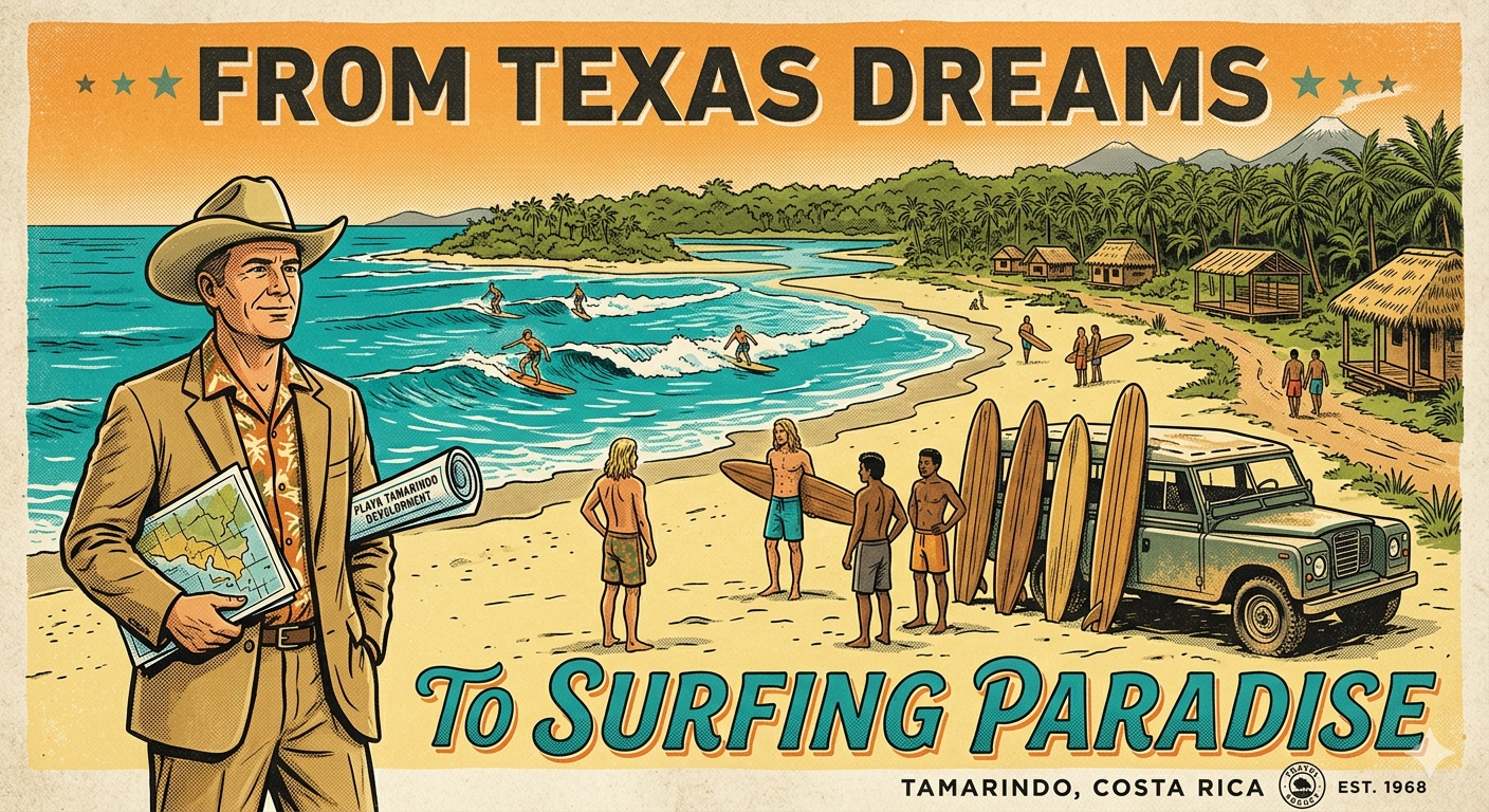
In 1985, a Texas businessman named Russell Wenrich drove into Tamarindo, assessed what he found, and bought land. He began developing beachside cabanas for the small but growing stream of international visitors who were making the journey to the Pacific coast.
Wenrich was not simply building accommodation. He was positioning himself at the intersection of something he correctly assessed as being about to grow significantly. His timing on the land was excellent. His eye for what was coming was better. Five years after his arrival, Wenrich met Robert August.
The Endless Summer II: The Film That Changed Everything
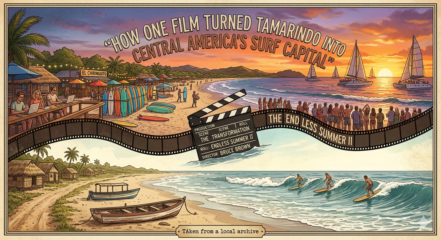
Robert August is a surfing legend. He was one of the two surfers at the centre of Bruce Brown's 1966 documentary The Endless Summer, the film that effectively introduced surf culture to the wider world by following two young Americans searching the globe for the perfect wave. That film became a cultural landmark, screened in cinemas worldwide and establishing surfing as something romantic, international, and worth seeking at the ends of the earth. By 1990, Robert August was looking for the right place to be. He found Tamarindo and, by most accounts, felt immediately that he had found something real.
The sequel to The Endless Summer was in development. Russell Wenrich, recognising the opportunity precisely, persuaded the Costa Rican tourism agency to subsidise the filming of Endless Summer II in Tamarindo. Bruce Brown brought his cameras to the Pacific coast of Guanacaste. The film captured Robert August surfing Witch's Rock, Ollie's Point, and the breaks at Tamarindo itself.
Endless Summer II was released in 1994 and opened with footage from Tamarindo. It reached a global audience and contained a very specific message: there is a place on the Pacific coast of Costa Rica where the waves are perfect, the beach is beautiful, and the pura vida is real. Come and find it.
The effect was not subtle. Tamarindo was not yet on any standard tourist map. After the film, it was on every serious surfer's map in the world.
1995: Infrastructure, Official Status and the Tourism Explosion
The year 1995 delivered two developments that together defined what Tamarindo would become. Liberia International Airport was upgraded to accept international commercial flights. And on November 27, 1995, Tamarindo was officially recognised as a district within the Municipal County of Santa Cruz, having previously lacked the residential population required for official status.
The airport was the key. Getting to Tamarindo before 1995 involved a drive from San José that took between three and six hours depending on conditions. With international flights landing in Liberia, the journey from the airport to the beach was approximately an hour. Tamarindo was suddenly accessible to travellers who would never have made the road trip from the capital.
Phone service arrived in 1996. The infrastructure gaps that had characterised the town for most of its existence were closing rapidly.
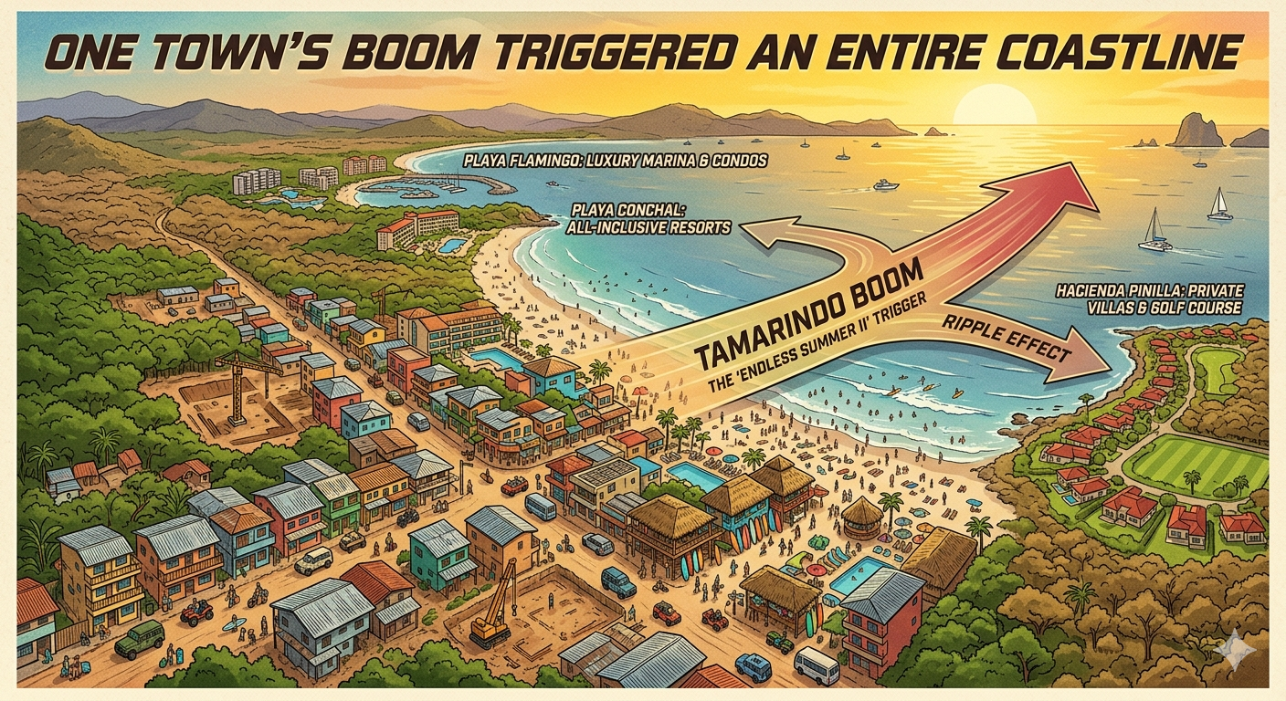
Robert August moved to Tamarindo full time in 2011, which tells you something about what the place had become by then. The man who had surfed these breaks on film and helped put Tamarindo on the global map chose it as his permanent home. The 2000s brought the development that transformed the town comprehensively: hotels, restaurants, surf schools, tour operators, real estate investment, the expat community that now makes up an estimated 15 to 20 percent of the population. Neighbour communities that had been equally quiet began their own development in Tamarindo's wake: Playa Flamingo, Playa Conchal, Hacienda Pinilla, Las Catalinas, all the resort and residential developments that now define the northern Guanacaste coast.
Tamarindo's growth triggered and funded an entire coastline.
Tamagringo: What the Town Became and Why It Still Works
Tamarindo is sometimes called "Tamagringo" by Ticos who note, not entirely affectionately, the density of North American and European faces in the streets, the international restaurant menus, the prices that match or exceed many American cities, and the way the town has been shaped more by tourism demand than by the rhythms of any local culture it replaced.
The observation is fair. Tamarindo is one of the most internationalised beach towns in Central America. Most of the people working in tourism here live not in Tamarindo itself but in the surrounding communities of Villareal, 27 de Abril, Huacas, and San José de Pinilla, because the town that tourism built became too expensive for the people doing the work of tourism to afford to live in. This is a tension that exists in every successful beach destination in the world and Tamarindo is not exceptional in having it.
What Tamarindo does have, and what makes the "Tamagringo" critique feel incomplete, is a genuine energy that is not manufactured and not replicated easily elsewhere. The surf culture is real. The BPM Festival and the Ocaso Underground Music Festival draw serious international crowds because the location and the vibe earn them. The sport fishing fleet is world-class. The food has genuinely improved to a level where Tamarindo now has restaurants worth seeking out rather than simply tolerating. Cala Luna in Playa Langosta, where I spent the back half of March, sits at the quieter, more intentional end of what the area offers, and it represents Tamarindo's best version of itself.
The estuary is still there, still navigated by crocodiles that have not altered their behaviour to suit the tourism industry. The waves at Witch's Rock and Ollie's Point are still the same waves that Robert August surfed in 1994. The pelicans still run their morning patrol along the surf line. The howler monkeys still conduct their pre-dawn meeting in the trees above the hotel gardens. The town that built up around all of this is noisy and complex and expensive and imperfect. It is also, when you understand what it was built on and how it got here, genuinely remarkable.
From 10,000 Years Ago to Today
The beach at Tamarindo has been a resource, a settlement, a fishing ground, a colonial periphery, a forgotten corner of a small republic, a surfer's secret, a film location, and a tourism phenomenon. Each of those chapters happened on the same sand, under the same sunsets, looking out at the same Pacific that the Chorotega fished from before anyone outside this coastline knew this place existed. I have spent months here across this trip, and what I keep coming back to is this: Tamarindo is worth more than most people give it. Not the instagram version of it. The actual version. The one with this history underneath it.
Go to the estuary. Stand at the water's edge where Adelita Zuniga dynamited through the hill to build the road. Watch the pelicans come in low over the surf the way they always have. Order a sunset cocktail at Nogui Bar, which sits in front of the spot where the original pochote tree stood when Adelita marked the boundary of her concession.
And remember that the Chorotega were here first, and were extraordinary, and deserve to be remembered as such.